 T.H.E.M.
¨We believe in the judgment; we believe this first judgment will take place as God revealed, in America...¨
T.H.E.M.
¨We believe in the judgment; we believe this first judgment will take place as God revealed, in America...¨
 T.H.E.M.
¨We believe in justice for all, whether in God or not; we believe as others, that we are due equal justice as human beings.¨
T.H.E.M.
¨We believe in justice for all, whether in God or not; we believe as others, that we are due equal justice as human beings.¨
Southern US to feel like middle of summer as record heat builds into this weekend
Southern US to feel like middle of summer as record heat builds into this weekend

Record-challenging heat will make it feel like the middle of summer across the southern United States through the weekend.
Dry conditions and plenty of sunshine will stretch from eastern Texas to Georgia on Saturday as an area of high pressure settles over the region.
Temperatures across much of this area will climb into the middle to upper 90s F, while farther west in Louisiana and eastern Texas, highs are expected to peak near 100 F.
“In fact, record highs may be challenged in several locations, such as Dallas, Houston and Shreveport, Louisiana, just to name a few,” AccuWeather Meteorologist Ryan Adamson said.
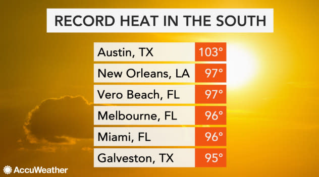
Several cities from Texas to Florida set new record high temperatures for the date on Friday, including New Orleans and Miami.
 |
Sweltering heat will spread farther north across the Southeast on Saturday in the wake of Hurricane Dorian.
Heat will peak in most places on Saturday with high temperatures ranging from the middle 90s along the Southeast coast to the lower 100s in eastern Texas.
Normal highs for the beginning of September across this region range from the middle 80s to lowers 90s.
It will feel even hotter across the region as AccuWeather RealFeel® Temperatures reach above 100 F. It may even feel as hot as 110 F away from the coast.
 |
Several record highs were tied or broken across the south on Thursday. In Vero Beach, Florida, which had been at risk from impacts from Dorian earlier in the week, the high temperature of 97 broke the old Sept. 5 record of 96 set back in 1996. New Orleans tied its record of 97; the last time the city hit 97 on Sept. 5 was in 2000.
Those along the Southeast coast left without power in the wake of Dorian will need to take extra precautions, such as drinking plenty of water to stay hydrated and taking frequent breaks in the shade during strenuous activity.
While Sunday will still be hot, the arrival of some spotty showers and thunderstorms can help to keep temperatures a couple of degrees lower from eastern North Carolina to the panhandle of Florida.
Temperatures will remain on the higher side into the beginning of next week, but more widespread showers and thunderstorms will knock temperatures down by a couple degrees in most locations.
“Temperatures should fall below 100 degrees in most areas by Sunday and Monday,” added Adamson, “but it will still likely be above normal for early September, with widespread mid-90s.”
Download the free AccuWeather app to keep track of temperature trends in your area. Keep checking back for updates on AccuWeather.com and stay tuned to the AccuWeather Network on DirecTV, Frontier and Verizon Fios.
Copyright 2019 Hiram's 1555 Blog